What to Know
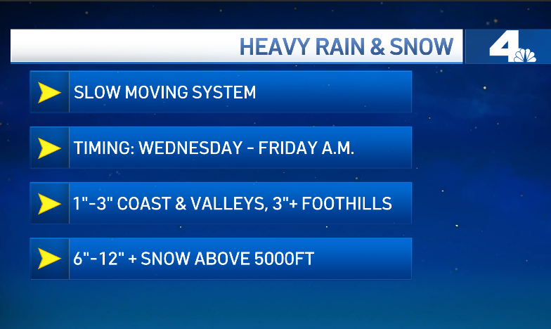
- Wednesday’s storm will be slow moving, and bring heavy rain to the Southern California area — up to 3″ in some areas.
- The slow speed of the storm means there are flooding concerns, continuing into the overnight period and Thursday morning.
- Area mountains will see significant snow, with a snow level as low as 5,000 feet.
Another storm is moving into Southern California on Wednesday morning, and this one is set to drench the area for at least two days in a soggy end to 2021.
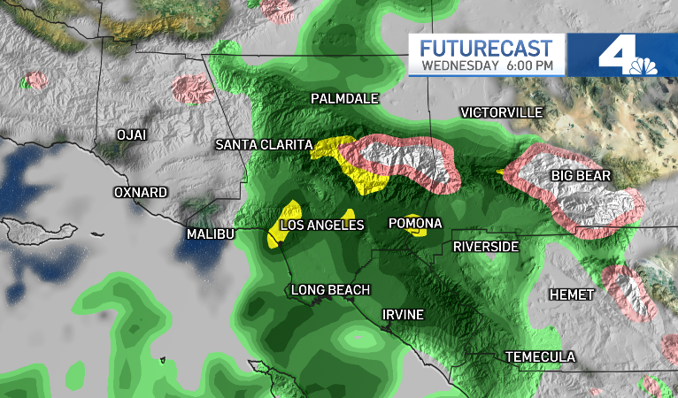
Rain will start over Ventura County around 9 a.m. Wednesday, but the slow speed of the system means Los Angeles County won’t see its heaviest rain until around 6 p.m.
The storm will stick around in that area for a few hours, bringing lots of precipitation to the region all the way into Thursday morning.
A winter storm warning was issued Tuesday night for San Bernardino County and Riverside County mountains, lasting until Thursday night. The snow level is expected to get as low as 5,000 feet, with between 6″ and 1′ of snow falling.
Though the storm will hover over the region for a couple of days, by New Year’s Eve and New Year’s Day, the weather will be dry and sunny again.
NBCLA Another storm in a series of storms will drop rain on SoCal. Here’s what to expect.
Timing
The storm is expected to start dropping rain over Ventura County around 9 a.m. Wednesday, moving very slowly into our area.
By noon, the system will just be starting to move into LA County, still soaking Ventura. It will be fully over LA county by 6 p.m.
Sometime between 6 p.m. and 8 p.m. Wednesday night, the storm will stop moving, hovering over the Los Angeles area. That stagnation will last into the overnight period, and the heaviest rain won’t move into the Inland Empire until around 4 a.m. on Thursday.
NBCLA Another storm in a series of storms will drop rain on SoCal. This one will move very slowly and last for a couple of days.
The heavy rainstorm stopping over LA County means flooding concerns for the area, continuing into the overnight period.
Heavy snow will fall in the area mountains the entire time. The snow will also be the longest-lasting part of the storm, continuing into Friday morning even after the rain has stopped for the rest of the region.
Expected Rain and Snowfall
The coast will see 1″-2″ of rain, though for the basin and inland locations, there could be as many as 3″.
The foothills could see even more precipitation, upwards of 3″ of rain.
In the mountains, the snow level will drop to around 5,000 feet, and there will likely be between 6″ – 12″ of snow.
Photos: Holiday Storm Images From Around California
Evacuation Warning
There is a voluntary evacuation warning in place for those in the Bond Fire burn scar area in Orange County.
That warning applies to residents of Silverado Canyon, Williams Canyon and Modjeska Canyon.
Winter Storm Warning
A winter storm warning was put in place Tuesday night for the San Bernardino County and Riverside County mountains.
The snow and icy conditions will make mountain travel difficult or impossible. If you don’t need to travel to the mountains before the weekend, wait to do so.
California Drought
Rain, Snow and California’s Drought
In October, the National Oceanic and Atmospheric Administration announced that a the Pacific Ocean was showing signs of a new La Nina, the flip side of the El Nino ocean-warming pattern, that tends to cause changes in weather worldwide.
Forecasters said much of California would have a 33% to 50% chance of below-normal precipitation, while only the state’s far northern tier had equal chances of above- or below-normal precipitation.
But the storm track has trended farther south than is usual during La Ninas. After a series of mid-December tempests, California’s overall snow-water equivalent — a measurement of how much water is in the snowpack — jumped from 19% of normal to date on Dec. 10 to 76% of normal on Dec. 17, according to the latest U.S. Seasonal Drought Outlook.
While the current wet trend is positive, it is too early to know if it will last through January and February. The snowpack normally doesn’t reach its maximum until April and last spring there was minimal runoff because much of the water was absorbed by the drought-parched landscape.
